First week
|
|
Home
Back First week |
|
|
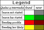
This is a control tool, used to help alleviate the threat to rural livelihoods posed by the bird pest Quelea quelea intermedia. The model attempts to forecast the breeding patterns of Quelea quelea intermedia over the whole of Eastern Africa. It is based solely upon Meteosat cold cloud duration (CCD) data as an estimate of rainfall and knowledge of Quelea quelea intermedia breeding biology. We make use of the simple GOES Precipitation Index, where temperature below -38 degrees Celsius is presumed to indicate cold cloud that is sufficient for rainfall to occur. Each hour of cold cloud is equated with 3mm of rainfall. The values for each quarter of a degree are summed and compared to the thresholds detailed below.
The Map Legend |
|
|
Darkening indicates Quelea quelea intermedia never recorded in this degree square. White shows the season has not started, or it is >5 weeks after breeding was last possible. Green denotes the season start, as greater than 60mm rainfall within a two week period. Red indicates breeding can start, as more than 240mm rainfall within a six week period. Yellow indicates no new breeding will start, as it is 6 weeks after breeding was first possible. |